Aaron McHugh
  • Start Here
  • Book
  • Podcast
    • All Episodes
  • Field Reports
  • Speaking
  • Workshop
    • Explorers Wanted
  • Free Guides
    • Learning to Pace Yourself: How to Keep Going
    • Road Trip Guide to California’s HWY 1
    • Free 7 day Course to Restoring Balance
    • 99 Ways to Navigate Your Best Life

Trip Report: Backpacking The Weminuche High Route

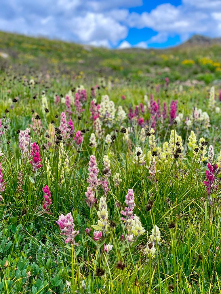
Deep in Colorado’s largest wilderness area, our adventure trio, Chris, Dave, and I, were hunting “spectacular plateaus of rolling tundra, ripsaw ridges, cliff-ringed lakes, and lush midsummer wildflowers” on The Weminuche High Route.

A quick snapshot: The Weminuche High Route (WHR), a 50-mile adventure hike, launches outside of Durango, CO, atop 11,000-foot Endlich Mesa, navigating endlessly north, zig-zagging up and down alpine valleys, passes, elk trails, stitching together old prospector claims, while overshadowed by behemoths peaks like The Guardian, Storm King, Silex, The Needles, Leviathan Peak, Jagged Mountain.

Thanks to our internal Swiss army knife of readiness, a handful of printed maps, and previous pioneer Steve Howe for the GPS tracks. We set out to explore this obscure backpacking high route.

“Leviathan Peak is the 236th highest peak in Colorado and is rarely climbed.” reads one website. No shit. High route veterans, even our party felt the intimidation factor. There is a gentler third class approach on the southwest ridge.

What drew us to this backpacking exploration

Previously, we’d underestimated our Colorado homeland opting for other more isolated mountain ranges like The Wind River of Wyoming and The Brooks Range of Alaska. Although in our home state, the Weminuche remains a six-hour drive away, further limiting infrequent exploration and miscalculating her renowned steep, jagged, and lonely alpine terrain.

The plan was hatched: 1) Explore more of our Colorado home. 2) The route is point-to-point. It starts south on Endlich Mesa, outside of Durango, CO, meandering north, dancing in the high places finishing 50 miles later by descending right into downtown Silverton. 3) The alluring size and scale of alpine giants-hundreds of summits.

I remember the legendary late alpinist Alex Lowe saying, “You can’t tell from down here what it’s like up there. You have to go see.” Our “crux” of the route looked much worse from far away. A spine of Weminuche boney crumbles midfield across a thirty-five -forty-degree slope. Once face-to-face, a pleasant ramp revealed itself with a simple class III move up. All good.

Sizing up the Weminuche High Route

How long will it take? Plan on five to eight nights. We packed food for six nights and finished the WHR in five nights-six days.

How many hours were you on the move every day? 7-10 hours each day. 

How many miles did you cover each day? Daily average: 8-14 miles daily, with 3200 to 4500 ft of vertical ascent. At some points, we were going SLOW when we were Off-trail, e.g., talus ascent, carefully at one mph. At other points, with a good trail underfoot, we could cruise much faster: e.g., on the Colorado Trail, for a tiny bit, we averaged 3+ MPH. But that never lasted long.

What was the vertical ascent/descent for the entire route? 16,291+ vertical ascent and 18,239+ descent.

Jagged Peak in the distance with a team of mountaineers descending from the summit. We could hear their voices, one of the few human contact moments we experienced all week. Inspired by a Hyperlite shelter promo ad, I brought along a pirate flag to remind us to stay playful. Guaranteed for a laugh out loud moment daily.

What can I expect and when should I go?

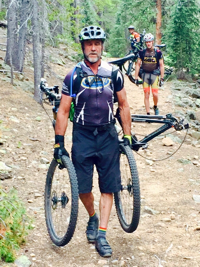
The WHR isn’t marked. No trail signs say, “go here, turn left.” It might look like we’re on a trail -just wait-ten feet later, it peters out, and you’re hunting for a new option. Losing the trail on a high route is par for the course. Scanning for game paths, old prospectors lines, elk hunters use tracks and bushwhacking up-down-across deadfall (down timber), creeks, spines, ravines, scree fields, talus, loose boulders strewn precariously descending alpine runouts. The rules of life on the WHR: walk softly, triple-check before committing to a turn.

The Pirates of the Weminuche High Route

Season: High summer promises the greatest ease of weather, no snow, river crossings are tame, and temperatures are moderate. Start as early as late-May and plan for snowy passes. September-October promises cooler temperatures and dry Indian Summer conditions with the risk of snow showers in the high places.

Fording Vallecito Creek was rumored to have a bridge, possibly swept by an avalanche in 2004. We never found it. Easily manageable in August, but beware during spring run-off (May-late June). The Weminuche High Route provided plentiful water sources every few hours-miles. Our team’s individual water treatment preferences range from Aquamira drops to Sawyer filters.

My Journal entries during our adventure

Day 2: Pirate flag makes me laugh. Each day, new guy carries on his pack. At night to signal happy hour begins at camp host’s tent
Day 2 evening: Deer walks into camp as we listen to Resilience meditation together
Day 3: Not everyone on our team thinks talus walking is fun
Day 4-5: Spontaneous shower in an alpine waterfall coming off Leviathan’s shoulder
Walked into Silverton: Swollen feet-a bit tired, but full. Sun-stained and wholehearted

Helmets are new to our packing list. With a brain bucket, we increased our summit dreams optionality. Although we resisted summit fever, we chose to wear our helmets when the terrain got precarious. Much of the Weminuche High Route travels where few people go. Those few souls we did encounter were climbing the summits, helmets required.

Getting there

From Durango: Plan to drive two-hours up to Endlich Mesa 4×4 vehicles required for the last 10 miles. After Arriving in Silverton, a preplanned shuttle recommended. No reliable Uber service.

Happy hour ritual started on our Alaska Brooks Range Trip, with homemade VIP ticket invites. In the Weminuche during a brief hail storm and “high’s-low’s” recap.

Gear worthy of mention:

I’ve upgraded the backcountry equipment I carry on these expeditions with a focus on ultra light. I’m no zealot over ounces, but I do appreciate stuff that works, stuff that holds up and reduces my base weight of 13-14 lbs (my pack weight including everything but food and water).
Hyperlight’s 4400 Southwest Ultralight backpack | Endlessly comfortable & simple
Hyperlite Ultralite Pyramid Tent | Weighting 1lb simple and roomy for two
Trail Design Sidewinder Tri-Ti 900 ML bundle Alcohol stove | Quiet minimalism
Footwear: Hoka’s Speedgoat 5 | Best support I’ve had in a decade

Resources:
The National Forest Service does not require permits for entering the Weminuche Wilderness Area. From the NFS, “The Weminuche spans the Continental Divide, North America’s geological backbone, with its headwaters diverted to both the Pacific and Atlantic oceans. Eolus, Sunlight, and Windom peaks rise above 14,000 feet, while many others reach above 13,000 feet. With an average elevation of 10,000 feet above sea level, the Weminuche is rugged country, but its ecosystems are fragile.”

Backpacker article with GIA GPS waypoints. Another perspective on the route, access details, and specific route details here.

Special thanks:
Ben @ Backcountry Experience in Durango for your stoke, support and last minute gear items we forgot.

As newlyweds, my wife and I worked for YoungLife’s Wilderness Ranch, each 1930’s rustic log guest cabin named after a Weminuche peak. Decades later, witnessing for myself Storm King’s prowess, sunrise glow, and Silex’s sheer intimidation (left).
Walking in a postcard, the Weminuche wildflowers abundant, vibrant, endless.
Alpine rock: Wham Ridge on Vestal Peak and Arrow Peak, the Weminuche Wilderness version of the Swiss Alps. Ultra-aesthetic twin towers for a future trip. Ropes required.
Rarely did we find three flat spots lushly welcoming our trinity to shelter so close to one another.
Alpine UBER: Thanks to our new friend Ben and fellow adventure enthusiast, he shuttled our trio up the ten-mile 4×4 jeep road to the top of Endlich Mesa to start. The skies unleashed minutes after this selfie capture. With the monsoon weather pattern proceeding our start, it turned out to be a rare storm shower all week.
Hyperlite Ultamid 2-Hyperlite Pyramid Shelter. Large enough for two, roomy for one person. 1 lb weight and pitches with two trekking poles lashed together. Easy setup. Bomber. No bug net in this configuration. Not cheap and no regrets.

Trip Report: Alaska’s Gates of the Arctic

“Alaska’s Ultimate Wilderness,” The Brooks Range-North America’s Northernmost mountain range is home to The Gates of the Arctic National Park and Preserve. In early June of 2021, our adventure trio Chris, Dave, and I, explored eighty-three trail-less miles inside the Gates of the Arctic. For eight days, we became Arctic residents in this expansive manless environment. Without human contact, constant silence, our fourth adventure companion.

A quick snapshot: Our intended exploration itinerary was to cross multiple high mountain passes, arranging for a bush plane pickup eight days later. To our surprise, winter’s blanket still covered the high peaks and mountain passes with waist-deep snow limiting our travel to the lower elevation glacial valleys. Slowly the Arctic awoke to spring’s animation accelerated by twenty-three hours of daylight and rain. River’s swelled as every hillside, peak, and knoll drained winter’s cold shroud.

Most of the locals appeared not to register what we were. Our wildlife log included the Western Arctic Caribou, Grizzly bear, Dall sheep, moose, Arctic fox, ptarmigan. Our tundra trio experienced a rare and elusive lone wolverine attempting to share our breakfast.

Walking up another nameless valley, west of Oolah Valley, this headwall looked like something from the Karakorum range in Pakistan. We often questioned what planet were we on, or which David Attenborough film were we in?

Why Go Here?
We went to see and experience a wild, undeveloped, rugged wilderness void of man’s intrusive disruption. Alaska’s Gates of the Arctic National Park and Preserve, located in the Arctic Circle, is as wild and untamed as early explorers discovered her in the 1880s.

Camp 4 underneath the Karakorum headwall, our lullaby was crashing ice sheets falling down the North face as the twenty-three hour daylight and rain rapidly accelerated winters retreat.

Some facts about “The Gates”
There are countless unnamed peaks, frigid crags, and endless tundra north of the divide. The park boundary is the second largest national park in North America, making it 3.5 times larger than Yellowstone. Containing no roads, trails, or signs, and if you underestimate what’s required, the National Park Service warns, you must be self-sufficient. There is NO ONE nearby if you run into trouble.

How long should I go for? A few days to weeks. Most groups require food resupply after 8-10 days. Our eight day, seven night trip was perfect.

Ascending to investigate will the snow provide a window of travel or will we be turned around?

Season: When asking the question “when should I go,” The Brooks Range has a complicated set of questions, trade-offs, and considerations to evaluate. See Andrew Skurka’s Quick Start Guide assess your options thoroughly. We arrived Mid-June which came with twenty-hours+ of daylight, requiring an eye mask to sleep and before mosquito season.

“Moose Alley,” we nicknamed this couple of mile head-high thicket. Endless brush, alder, and willows towering over-head and impairing our view. We followed Moose scat up the riverbed, gauging “how fresh is that scat” anxiously wanting to avoid surprising a 1,000 lb. Alaskan bull moose.

My Journal entries during our adventure
Day 2: Terrain is a Star Wars movie. Endless valleys, wide sweeping glacial remnants. The hills are dormant-not awaken to alpine summer.
Day 2 evening: Out and up unnamed valley toward unnamed pass. Lots of deep snow. Decided to turn down after watching a small snow slide break across our path. Full hearted day as friends as brothers.
Day 3: Grizzly bears, caribou, arctic fox, moose-a regular alpine zoo. Amazing. Big river we decided not to cross-swollen, fast.
Day 4-5: No entry. Guess, I was too tired. Nursing an Achilles heel injury I brought with me.
Day 6: “God is the country in which I live” Eugene Peterson
Pickup day: @ landing strip, crossed river last night after we pitched our tents on a windy ridge. Decided to walk to here instead. Awaiting Dirk’s pickup, Coyote Air 1953 bush plane “Pumpkin”.

Coyote Air owner and Alaskan bush pilot veteran Dirk dropped us above the frozen Oolah Lake straight onto the tundra landing strip. Unloaded our gear, checked that the wind hadn’t changed, and down-winded into his takeoff for home. Returning eight days later to retrieve us and fly back to Coldfoot, AK.

Getting there by bush plane
Custom charter air taxi “bush plane” service from Coyote Air in Coldfoot, AK. Our pilots, Dirk Nickish & Danielle Tirrell are seasoned Arctic veterans. Getting to Coldfoot: From Fairbanks or Anchorage, AK, fly Wright Air or drive the Dalton Highway five to six hours from Fairbanks. Getting to The Gates required a total of four airline legs. Denver to Anchorage, to Fairbanks, to Coldfoot, to the Gates of the Arctic drop point to begin our adventure. Plan on enjoying the Alaskan experience where the weather influences every schedule. In total our air travel cost was around $2,000.

Evening happy hour ritual with a finger or less of whiskey, a music playlist chosen by the tent host. Priceless. I scratched handwritten VIP invitation tickets for each of the fellas, “Come join me for happy hour.” Chris retained his VIP ticket, it sits bedside back at home to today, a reminder of the beauty in little things. These wild places remind us that we are proud owners of everything that can’t be purchased.

Gear worthy of mention:
I’ve upgraded the backcountry equipment I carry on these expeditions with a focus on ultra light. I’m no zealot over ounces, but I do appreciate stuff that works, stuff that holds up and reduces my base weight of 13-14 lbs (my pack weight including everything but food and water).
Feathered Friends Helios Hooded Down Jacket
Hyperlight’s 4400 Southwest Ultralight backpack
Sierra Design High Route 1 person shelter
Trail Design Sidewinder Tri-Ti 900 ML bundle Alcohol stove

My favorite piece of gear for this trip was my Feathered Friends Helios down hooded jacket. Instant warmth, compressible and easy-to-access pockets to plunge in cold hands. Pictured here heating up our breakfast “cuppa” after a few hours of walking over tussock. “A tussock is a large knob of soil with tufts of grass or sedges growing on top. They range in a variety of sizes, and are a notable obstacle when walking.”

Resources:
Andrew Skurka has extensive experience exploring the Brooks Range and provides backpacking enthusiasts helpful resources: A quick start guide, a gear list for June, and details about their guided trips.

When the sun came out, the rain stopped, we danced like kings, Tundra Tough kings. The expansiveness of the place held big questions like “Who is God? and What’s God really like? What’s next for me in this season?” Our buddy Dave was getting married in a few months, and we explorers-the wedding party-the minister, groom, and best man.

Special thanks:
Dave Eitemiller, the Pathfinder, put this trip together with his extensive Arctic experience and love for analytics, logistics, and planning. He deserves special thanks as well for many of these photos. Thanks to Andrew Skurka and the opportunity to benefit from your six-month exploration of the Brooks Range.

A letter from home, a picture for each day my lovely wife hid in my pack before departure. So invigorating to open each day.
Springs emergence become more evident by the day. The gift of arriving mid-June, we witnessed the daily awakening of subtle colors of life.
Weeks later, our buddy Dave still guiding in the Gates, reminded us of how majestic the Arctic tundra became after our departure. We must go back and see it ourselves.

Trip Report: Backcountry Ski Hut to Hut

Description: The saying about backcountry skiing goes, “free the heel, and you’ll free your mind.” After a handful of Colorado winter backcountry ski adventures, I’m hooked. Last winter, we linked these two 10th Mountain Division Colorado Huts together. Ski into Jackal Hut from Camp Hale (4.7 miles) and then onto Fowler/Hillard Hut (via 7.8 mile Pearl Creek), back to Camp Hale. Skiing hut-to-hut deepens the backcountry experience of breaking trail and navigating between huts. For a smaller one night adventure, start with skiing or snowshoeing directly into Jackal Hut. Reservations required. 

Length: One to four days

The rewards: Hut trips, with the right group, can be extraordinary experiences. Our groups are always carefully selected with a match of great people and the appropriate experience level. NOLS (National Outdoor Leadership School) claims for everyone to have a good, safe time, you must display “Expedition behavior.” 

Season: Late Winter to early Spring

Keep going-

Aaron

Onward Camp Hale style approaching the winter storm. With a big group it’s important to use the buddy system. No one left behind.
When the sun is shinning, bluebird Colorado winter skies, a positive mental attitude is easy to find.
Fresh tracks, sunshine, close friends, miles away are the rewards of backcountry hut skiing.
Navigating between huts requires additional know-how using map, compass, GPS and breaking trail. Advanced level skills required.
Like a postcard, these rare moments, living fully alive.
Unlike the ski resorts, there are no groomed trails. Deep powder, mixed terrain makes for a playground of joy. Sometimes you might need a buddy to help you up 🙂

Trip Report: 75 stories Underground in Carlsbad Caverns National Park

Description: In 1901, eighteen-year-old cowboy James Larkin White witnessed a moving black cloud over the Chihuahuan Desert of southern New Mexico. Brazilian free-tailed bats were feeding at dawn and dusk, swirling above one of the most spectacular caverns and underground wonder. Today, Carlsbad Caverns National Park is accessible by walking 1.25 miles down a long steep ramp, winding into the cavern’s mouth. Carlsbad is the largest easily accessible cave chamber in North America. Backcountry caves are also accessible for the adventurous, requiring permits and technical caving equipment.

Length: One to two days

The rewards: Our spring break father-son party explored both the famous main cavern and one backcountry cave, which I can’t recommend. Our teenage boys didn’t find the experience of bushwhacking through cactus and up tangled desert trails rewarding. After rappelling into the slit access, we opted for a retreat.

Season: Spring, Fall, Winter

Keep going-

Aaron

The main entrance into Carlsbad Caverns. Smooth walking trail of 1.2 miles descending into the main caverns.
Our boys after being dejected from our backcountry (non-tourist route) spelunking adventure at Carlsbad Caverns.
The mighty great room Carlsbad Caverns.
Adventure Carlsbad Caverns picking our way back to the car after aborting our spelunking descent into the abyss.

Trip Report: Hiking the Narrows Zion National Park

Description: There is no trail, only river and wet feet. Hiking the Narrows in Zion National Park is one of the most unusual slot canyon trail experiences you’ll find. Hiking up the Virgin River, most people begin at the Temple of Siniawava on the Riverside Walk. Walking upstream as far as your adventure spirit leads. Throttle your adventure from a two to ten mile aquatic romp walking, wading and swimming. Before you hike-check the weather.

Length: A few hours to a full day

The rewards: A challenge that you can throttle up or down based on your party. Family friendly, but probably not a place for kids under the age of 8-10. Endless beauty, unique and memorable desert experience. Time your adventure in the off-season of Fall or Winter to reduce the crowds and watch the weather forecast for rain. The canyon is prone to flash floods.

Pro tip: Rent gear including wetsuit and rubber booties.

Season: Spring, Fall, Winter

Keep going-

Aaron

Before you step foot into the Virgin River, the trail meanders upstream.
Starting the Narrows trail. Notice how wide the slot canyon walls are here at the beginning.
Exquisite beauty in the Zion Narrows with contrasting vivid colors from emerald green to crimson red.
The Narrows slot canyon pinches down to
The Narrows can be a zoo or you can find yourself alone in moments of solitude. In November, I shared the experience with a handful of other explorers.
Just outside of the National Park, Zion Adventure Company was dialed in for enhancing your Narrows adventure.

Trip Report: Below the Rim at Bryce Canyon National Park

Description: Bryce Canyon National Park’s infamous crimson-bandit hiding hoodoos and endless vistas remnants of erosions sculpting. I drove our 1974 VW Joy Bus from Colorado to locate a trail that my mother hiked in the 1960s. My only beta, a picture of a slide and a faint recollection of a family road trip story.

Length: One to three days

The rewards: Although the rim’s views are stunning, the real immersion experience of Bryce Canyon exists below the edge. A few hours to multi-day backcountry routes, get up close and intimate with this desert southwest bizarre landscapes. Find them under the rim trail guide here.

Season: Spring, Fall, Winter

Keep going-

Aaron

Snapped on a brief below the rim wandering, my mom’s 1960-era trail recollection was faint. Finding this Bryce Canyon trail became my mission.
These mighty giants commanding presence were inspiring. Very little water, enclosed by a hoodoo fortress, the hidden life of trees in Bryce Canyon.
I’m not certain, but my mom’s 1960’s trail had some similarities in this region of the park. Guess I’ll need to go back to certify my find.
As with any wild place, the further you get from the car, there are fewer people. Fellow explorers returning from a multi-night backpacking trip via Navajo Loop.
Bryce Canyon’s contrast of hoodoos and lonely pine trees is somehow a parable.

Trip Report: Mountain Bike the Colorado Trail (and hike sections you can’t ride)

Hey, y’all! This summer, I finished the 488 mile Colorado Trail (over 562 on a bike). In 2015, I joined a team of dirty dozen, over twelve days to mountain bike The CT from Durango, CO to Denver, CO. This summer, I returned to the Collegiate Peaks wilderness area (CT West loop near Buena Vista) to backpack an unfinished 70-mile section where mountain bikes are not allowed.

Above Camp Hale we discovered unending fields of wildflowers and bluebird skies.

Never heard of The Colorado Trail (CT)?

A few stats to bring you up to speed.

  • Shorter than the Appalachian Trail (2,190 m) or Pacific Crest Trail (2,650 m) means that you don’t have to quit your job to engage this epic trail.
  • Most of the trail is above 10,000 feet, the high point of 13,271 feet.
  • The total elevation gain for a thru-bike/hike is approx 90,000 feet, equivalent to three Mount Everests.
  • Lots of resupply mountain towns and places for friends to join in, e.g., Silverton, Buena Vista, Breckenridge
  • The thirty-three segments enable adventurers to bite off a small section or two over a weekend or take on the entire trail over a few weeks.
  • The mountain bike Fastest Known Time is held by Jakomait, finishing the 562-mile course in a record-breaking 3 Days 20 Hours 46 Minutes. OUCH! (It took us 12 days).
  • Hikers take 4-5 weeks to thru-hike the CT.
On top of Stony Pass above Silverton, CO was an amazing flowy, alpine playground. In parts, pushing our bikes up steep inclines but rewarded with other-worldly beauty.

Why did you do it?


Moving to Colorado in 1994, the allure of the CT pulled on me. I want to see every corner of Colorado, and I knew this was the grand tour. Secondly, our buddy Gill McCormick had cooked up this trip of the decades-each member representing a decade of life. One member of our party, Jim, was in his 60’s (fantastic guy who had a Mary Poppins like Camelback that produced anything you needed), multiple guys in their 50’s, 40’s, Alex in his 30’s Connor (20), and Grant (17). The story was the hook for me. The dirty dozen, spanning six decades, two CT veterans, and a support vehicle to shuttle our gear between camping spots (Thanks Skyler). I was in.

The team at the beginning. The Dirty Dozen beginning the Colorado Trail 500+ mile ride.

What was the hardest part?


“Yesterday was the only easy day” is the quote I remember replaying in my head. I don’t recall any part being easy, but I think the most significant mental challenge was the day we carried our bikes for 8+ miles through the Lost Creek Wilderness. It is illegal to ride your bike within Wilderness Areas, and we were at a fork in the road. We had two options 1) to ride 75 miles around “wilderness detour” or 2) to hike 8+ miles carrying our bikes attached with bungee cords to our Camelbacks 😜. We chose option 2.

We were 8-9 days into the epic adventure, and everyone was exhausted already. Before the hike-your-steed section, required a tough 25-mile ride to access the Wilderness Boundary. Dismount. Disassemble and jury-rigged, we began the bike carry (sufferfest). Across the trek one guy lost a linchpin bike part, which would have rendered his bike unrideable. Miraculously another guy picked it up in the forest. We remount bikes and rode 20+ more miles to find camp.

There were a lot of expletives gurgling in those woods. Still today, we refer to that carry-your-bike as the “Chernobyl Meltdown.” It wasn’t glamorous. Afterwards, forgiveness needed extending between a few of us, and like every low point, we’re either better or bitter from it. Everyone expanded their capacity to dig deeper that day.

A picture is worth 1,000 words. Look at our faces and imagine if you were with us.

What was your favorite memory?


Alex and I shared a tent for two weeks. Rain, snow, sunshine, snoring, and twelve-hour grueling days together deepened our friendship. Our friendships among many of us deepened from the shared transformation and joy we experienced on the CT.

The infamous high point of The Colorado Trail 13,271 ft which is amazingly high altitude to be riding your bike. After this section, we were met with a punishing twenty+ miles of tundra-talus-shale.

What was your favorite part of the trail?

It was foggy, rocky, and steep to the summit of this 12-13,000 foot peak. The dozen of us strewn like pearls on a necklace across the spiny alpine swatch, I knew that moment was special.

Early in our ride optimism was high and everyone still feeling great and happy to be on this big adventure.

What did you learn about yourself?


How to keep going at a new level. My suffer meter maximum moved forward a lot. Previously competing in endurance events like Ironman triathlon defined my one-day effort threshold. Substantial efforts no doubt, and at the end of the day, I went home and slept in a warm bed after a nice hot shower. The CT demanded that I expend a similar level of endurance effort today, and then do it again tomorrow and the next day. Holy crap! My boundary limits transformed in the cauldron of the CT. “Hard” now has many levels.

The combination of duct tape and Hello Kitty bandaids to help reduce the friction on my back where my Camelback rubbed daily.

Why did you go back to backpack the Collegiate West section?


In 2015, each time we encountered a wilderness boundary, we would “ride around” via the bicycle detour and rejoin the official CT again once bikes were allowed. There are five bicycle detours in total. We rode three, bike carried one 🙂 and accepted a ride for #5.

Watching from the truck’s passenger seat, for me, that 70+ mile Collegiate pristine wilderness section always felt unfinished. In the moment, I was too tired to deny the transport. Years later, like a developing ulcer, skipping that section ate at me, and I wanted to touch every mile I could officially. My solution? I did a five-day solo hike from Tennessee Pass south to Cottonwood Pass and celebrated with ice cream from K’s Dairy Delight in BV.

I believe just beyond Bear Lakes on my first night solo effort to complete the CT. Amazing beauty, no motorized vehicles, very few people and untamed wilderness for miles.

What advice do you have for anyone considering the CT?

Know your Why
With a trail this long and arduous, you will need to know, “WHY am I doing this?” before you start. Decide what style you want to define your experience
-Slow, steady to fast?
-A section at a time over many years or all at once?
-Supported by friends bringing you supplies or self-supported?

I’m aware of the importance of defining your style and not attempting to repeat another person’s adventure. I met a few folks along the trail that depict the saying, “Run your own race.”

  • A guy in his 50’s that said he’s 0-for-5 starting from Denver ejecting for different personal & professional reasons. We gave him a ride into town, aborting his 5th attempt.
  • The previous fastest known time on a mountain bike was four+ days. I hear that he has permanent nerve damage in his hand and ankle.
  • In the Collegiate Peaks sections, one guy passed me flying by. Later I learned that he was speed hiking 48 miles into his 58 for that day. Most people hike between 13-20 x day. I bet he’s one of the Avengers.
  • A young woman just finished grad school and was ten days into a four to five-week hike. She was craving fresh fruit. Her East Coast mother, who doesn’t camp, texts her nightly on her Garmin InReach to confirm bears hadn’t eaten her.
  • A couple seasoned in age helped each other across a creek—half-way into their 488-mile trek. I can only imagine their kid’s phone calls, “Have you heard from Mom and Dad? What are they thinking?!”
Our Dirty Dozen in 2015, atop Fooses Creek nearing Monarch Ski area, working our way towards 1/2 way to Denver.

What hard lessons did you learn?


Two stand out. Saddle sores are real and check for the latest maps before you go.
Saddle sores: By far, the most significant source of pain our mountain bike crew experienced was from saddle sores. Yep precisely what you think of. Sores on your undercarriage resulting from twelve-hours of daily friction. Some guys needed to dial back their daily ride time to accommodate for their pain. It was no joke.

I don’t recall which pass this was early in our ride leaving Durango. As we pushed our bikes, we learned carrying them on our back was more effective.

Latest maps: Returning five years later to hike the Collegiate West section, I assumed that my old data book was reliable. I pulled together two additional supporting maps from my library and felt a pause in my gut. “Maybe I should swing by the gear store in BV (The Trailhead-love these guys) and grab a map?” The moment of truth and reconciliation unfolded while crossing Cottonwood Pass, out of water, at 12,000 feet and chased by a thunderstorm “What? Where am I?” It turns out that sections of the CT are now rerouted to share the Continental Divide Trail (missing on my older maps). Glad I stopped for the new map.

The Colorado Trail data book outlining each of the 33 segments. The “New” map showed the correct route, but my older edition data book didn’t. Great lesson to learn again.

Trip Report: Black Canyon of The Gunnison National Park

Black Canyon of The Gunnison National Park is “big enough to be overwhelming, still intimate enough to feel the pulse of time.” One of the least visited National Parks, which means if you venture below the rim, share your experience with a reverent few. Hard to reach, steep, rocky, poison ivy, unmarked trails reward the adventurer, climber, fly fisherman.

Two-miles down the S.O.B draw to meet the infamous Gunnison River

Exploring The Black Canyon

Length: One to three days

Description: From the top, the Black Canyon is impressive, and her dizzyingly steep canyon walls are best witnessed from below where direct sun reaches only a few hours daily. We packed in our fly rods to experience the legendary Salmon Fly hatch and gorging trout. We opted for the The North Rim accessed by a dirt road climbing out of Crawford, CO. What became evident was how the preservation of this ancient place is aided by its no frills amenities. Void of a big lodge, plentiful rim hugging campsites, and gnarly descents, the Black Canyon is wilderness at it’s best.

Route description down the S.O.B draw
“There are no maintained or marked trails into the inner canyon. Instead, there are “wilderness routes,” or unmarked scrambles to the river. Only individuals in excellent physical condition should attempt these routes; they are not meant for small children.

Hikers are expected to find their own way and be prepared for self-rescue. While descending, study the route behind, as this will make it easier to wayfind when confronted with a choice of routes and drainages on the way back up. The routes are the easiest, and sometimes only, path to the river.

Poison ivy is nearly impossible to avoid, and can be found growing 5 feet tall along the river.”

The rewards: Hungry trout, solitude, and timeless beauty.

Season: Spring, Fall

Two thousand plus vertical feet of Painted Wall.
Fly rod in hand, boulder hopping and fishing technical drifts where trout out number humans.
Flat and soft spots are rare for a tent in the Black Canyon
Fishing at twilight under the Black’s Mordor like gates

Navigate a life worth living

Sign up to receive regular emails about living a fulfilling and meaningful life

Sign Up

Copyright © 2025 Aaron McHugh

About

  • About Aaron
  • Book
  • Joy Bus
  • Contact

Learn

  • Podcast
  • Field Reports

Events

  • Speaking
  • Workshop
  • Coaching

Free Guides

  • HWY 1
  • How to Keep Going
  • Restoring Balance
  • 99 Ways

Follow Aaron